Ratings & Reviews performance provides an overview of what users think of your app. Here are the key metrics to help you identify how your app is rated by users and how successful is your review management strategy.
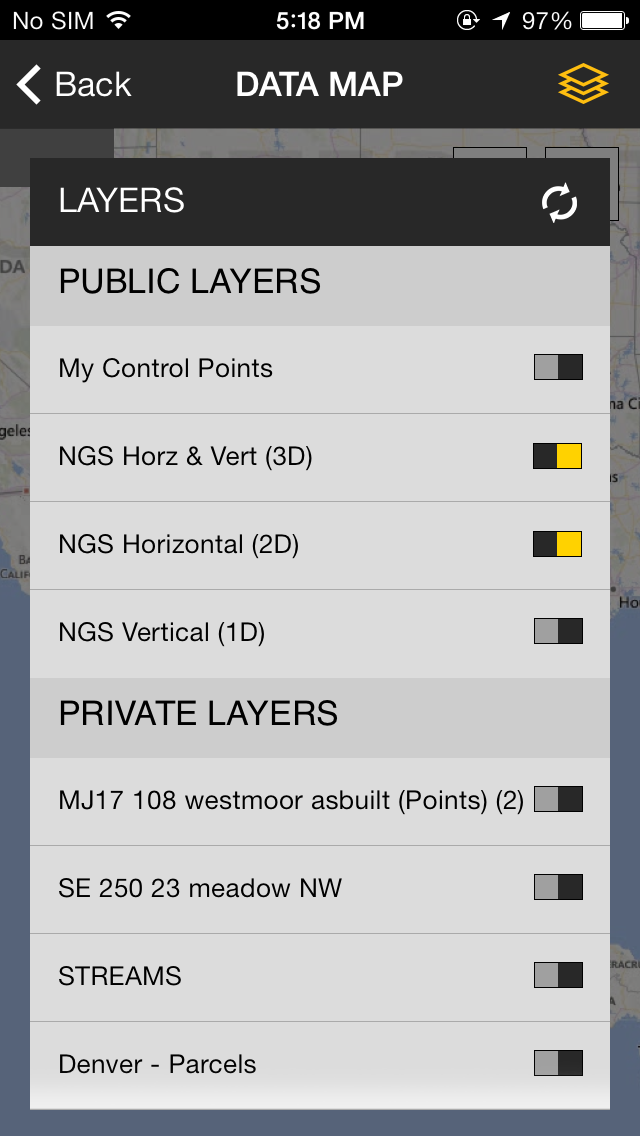
The Trimble® InSphere™ Data Manager application enables central management of your organization’s geospatial information, accessible anytime, and anywhere. GEOSPATIAL information – ALL IN ONE PLACE The Trimble InSphere Data Manager application allows users to securely manage geospatial data in one place, improving access to data for the whole organization. Data Manager allows you to quickly access, search, and view geospatial information and survey control points using an intuitive interface. View layers from different information sources at the same time, including public survey control information. SAVE TIME AND IMPROVE PRODUCTIVITY Geospatial organizations can efficiently reuse collected data in new projects. Instead of starting a new project from scratch, project managers, survey managers and field crews can save time by incorporating previous project information or control points into new project field packages and assignments. Simply center the map around a new project location and immediately see which projects you’ve done nearby and what data is available for reuse. Selecting features on the map allows you to see their detailed attributes and export them to a CSV file to send to the field. ACCESS – ANYTIME, ANYWHERE InSphere Data Manager delivers simple and effective information management for geospatial professionals, enabling access anytime and anywhere via a web browser on a desktop or on a mobile device. Managers in the office can quickly discover reusable information from previous projects and incorporate them into estimates and assignments. Project managers and field crews can easily obtain nearby control points to a location using the mobile application. TRIMBLE INSPHERE FOR INTEGRATED APPLICATIONS Data Manager is part of Trimble InSphere, a cloud-based software platform for central management of geospatial applications, information and services. Trimble InSphere allows geospatial professionals access to an ecosystem of integrated applications, including Data Manager, Equipment Manager, TerraFlex™ software, and Trimble Access™ Services. Features: View Project Information on Map –– See an overview of what projects and control points are available in the area –– See available project information on your map and choose which data to display View Feature Attributes ––Click on any feature on the map to see its detailed attributes View NGS control points (U.S. only) ––Quickly see what NGS control points are available in the project area Export to CSV ––Select a control point from the map view and create a .CSV file for exporting to the field Navigate to Point ––A Compass shows you which direction to walk and how far to help you locate control points Support for multiple data types ––View information from VCE, SHP and KML files together in one place